


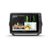


Garmin ECHOMAP™ Ultra 106sv | With Transducer & Chartplotter
$2,789.99
-
The sunlight-readable 10” touchscreen combo features preloaded BlueChart® g3 charts and LakeVü™ g3 maps, and the transducer bundle adds CHIRP traditional and Ultra High-Definition scanning sonars. The keyed-assist 10” touchscreen puts fishfinding know-how at your fingertips. See crisp images of structure and fish in stunning detail. Navigate confidently with preloaded BlueChart g3 charts and LakeVü g3 maps. Manage your marine experience from nearly anywhere with the ActiveCaptain® app1. Connect your boat to share data, sonar and charts with your other compatible devices. Explore your new favorite spot; create maps on the fly, and tailor them to fit your needs.
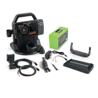
In the Box:
- ECHOMAP Ultra 106sv with BlueChart g3 and LakeVü g3 for U.S.
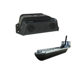
- GT56UHD-TM transducer
- Power/data cable
- Tilt mount with quick release cradle
- Flush mount
- Protective cover
- Hardware
- Documentation
1Requires the ActiveCaptain App on your compatible smartphone paired to the ECHOMAP UHD 72sv
-
General
Touchscreen
Dimension | 11.6" x 7.7" x 3.9" (29.5 x 19.5 x 9.8 cm)
Input | Touchscreen with Keyed Assist
Display Size | 8.5" x 5.4"; 10" diagonal (21.7 x 13.6 cm; 25.4 cm diagonal)
Display Resolution | 1280 x 800 pixels
Display Type | WXGA, IPS
Weight | 4.0 lbs (1.8 kg)
Waterproof | IPX7
Mounting Options | Bail or flushMaps & Memory
Accepts Data Cards | 2 microSD cards
Waypoints | 5000
Track Point | 50,000
Tracks | 50 saved tracks
Navigation Routes | 100Sensors
10 Hz Receiver | Has Built-In Receiver | NMEA 2000 Compatible | NMEA 0183 Compatible | GPS | Supports WAAS |Built-in Maps
BlueChart (Coastal) | LakeVü (Inland) | Tide TablesOptional Map Support
Bluechart G3 | Bluechart G3 Vision | LakeVü G3 | LakeVü G3 Ultra | Garmin Navionics+™ | Garmin Navionics Vision+™ | TOPO | Standard Mapping | Garmin Quickdraw ContoursChartplotter Features
AIS | DSC | Supports Fusion-Link™ Compatible Radios | ActiveCaptain® Compatible | Sailing FeaturesElectrical Features
Power Input | 9 to 18 Vdc
Typical Current Draw at 12 VDC | 2.8 A
Maximum Current Draw at 12 VDC | 3.0 A
Maximum Power Usage at 10 VDC | 24.4WSonar Features & Specifications
Displays Sonar | Panoptix™ Sonar | Livescope
Power Output | 600 W
Traditional Sonar (Dual Frequency/Beam) | built-in (single channel CHIRP, 70/83/200 kHz, L, M, H CHIRP)
ClearVü | built-in 260/455/800/1000/1200 kHz
SideVü | built-in 260/455/800/1000/1200 kHzConnections
1 NMEA 2000® Port | 1 Connections NMEA0183 Input Port | 1 NMEA 0183 Input (TX) Port | 2(Large) Garmin Marine Network Ports | 1 LVS sonar; 1 scanning sonar 12-Pin Transducer Port -
Customers who viewed this item also viewed
-
Humminbird Ice HELIX 7 Chirp GPS G4 All Season
Sale Original price was: $1,379.99.$1,183.99Current price is: $1,183.99. Add to cart -
Lowrance StructureScan 3D Transducer and Module
$1,500.00 Add to cart -
Minn Kota Prop – Weedless Wedge 2 / MKP-33
$69.99 Add to cart -

Minn Kota i-Pilot Remote-Bluetooth
$254.99 Add to cart
